Mars Arctic Research Station
A Mars Society Project

Haughton Crater, Devon Island, Nunavut, Canada
• Home Page
• Latest News
• Why Devon Island?
• Technical Specs
• '99 Reconnaissance
• Get Involved
• Weather
• The Team
• TF Members Login
• Mars Society
Have questions about this site? Contact Marc Boucher or Thomas Gangale, Webmasters.
The Mars Society.
All rights reserved.
Some images
copyright © NASA
All rights reserved.
The following is a journal of my trip to Devon Island as part of the reconnaissance expedition for
the Mars Arctic Research Station (MARS).
Friday, July 23, 1999.
I leave Denver to arrive at Edmonton, Alberta. Edmonton is a modern city, not too different from
the kind of place where most Americans and Canadians live. There is one difference, however; a
distinct hint that this is a jumping off port for wilder places. At the Nisku Inn where I stay, the
décor is Alpine and everyone is leaving for points north.
Saturday, July 24, 1999.
I leave Edmonton to arrive at Yellowknife, in the Canadian Northwest Territories. Here I meet Kurt
Micheels, the MARS project architect, and George Dunfield, an engineering geologist who is joining
us to take geotechnical samples at candidate base sites. These samples are necessary in order to
assure that the base module can be firmly anchored in the ground against the high Arctic winds. We
are scheduled to fly on to Resolute, in the far north, but the airline informs us that Arctic
weather prevents further advance today. Our flight is delayed 30 hours, with departure set for
11:45 PM Sunday. We check into the Yellowknife Inn and proceed to explore the town.
Sunday July 25, 1999.
Yellowknife, population 20,000, is a real town, with stores, and a supermarket, and what not, but
the flavor of the frontier is all over it. Located about 65 degrees north, it is the last stop for
those heading to the high Arctic, and many such can be met here. The surrounding territory is
sub-Arctic in character, with lots of small evergreen trees and cold lakes filled with fish. The
geology is ancient; the Canadian Shield rock the town sits on is 3.9 billion years old - 80% the
age of the Earth and 30% the age of the universe (!). Hiking about together, I share my speculation
with Kurt and George that given their cosmologically significant age, that the laws of the universe
may have changed a bit since these rocks were formed, and perhaps some way to detect such change
could be accomplished by examining them. At midnight, we take off for Resolute, heading due north
into the sun.
Monday, July 26, 1999.
We arrive in Resolute, a desolate base 72 degrees N, about 3 AM. The sun is up, but it is cloudy
and so it seems like dusk. We are taken to the Polar Shelf agency dormitory, where we sleep two to
a room on bare beds under parkas or in sleeping bags until 7 AM when we wake for the trip to Devon.
I inhale my breakfast, Kurt abandons most of his, and George gets none when the pilot of our
Twin-Otter unexpectedly advances the departure time by half and hour. Scrambling out to the
airfield we meet NASA's Carol Stoker and the Canadian Space Agency's flight surgeon Gary Gray, who
accompany us on the flight to the crater.
We arrive at the Haughton impact crater on Devon Island around 9:30 AM. The whole base camp crew of
about 20 people turns out to meet us and help unload the aircraft. It is obviously a major occasion
here when an aircraft arrives. As soon as the plane is unloaded it departs, and Pascal Lee
assembles everyone for a briefing. Going around the group, he introduces everyone (both existing
crew and new arrivals) identifying their skills or mission or assignment. He then proceeds to
announce what everyone will be doing today. All of us in the new group will be heading out with
Pascal and several others to examine the several candidate sites that Pascal and the team have
identified as possibilities for the Mars Arctic Research Station. Before we leave however, we are
given another briefing on the handling of the anti-polar bear weapons (12 gage pump action shotguns
loaded with heavy steel slugs instead of birdshot) and the All Terrain Vehicles (ATVs) by an
experienced guide named John Scutt. John looks the part of an Arctic guide with his mountain-man
beard, but conversation quickly reveals that in addition to being a crack Arctic hand, he is also a
very knowledgeable geologist. After some training with these items we have lunch and then set
out.
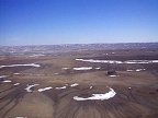
The weather is cloudy and cool, perhaps in the high thirties, but in its own way the crater is as
beautiful as any place on Earth. As we set our through it on our first ATV sortie our spirits are
the highest imaginable. The crater is a crater, and journeying through it you know it, as sloping
ridges of breccia created by the 23 million year old meteorite impact are visible in all
directions. The landscape is alien; there is almost no life. Here and there is a spot of moss or
lichen on a rock, more occasionally one sees a wildflower. When this happens, your eyes gravitate
to it, almost instantly, as if you are meeting a friend in a strange place. There is air, there is
some water. But without life, a place does not seem like a part of our home planet.
The crater is huge, about 10 miles in diameter. This makes it an order of magnitude larger than the
Arizona meteor crater, and an order of magnitude smaller than the 100 mile crater left over from
the Yucatan even that destroyed the dinosaurs. The blast that created it exceeded 1 million
megatons force. By comparison, Mount Saint Helens was 7 megatons, and a full scale nuclear war
between NATO and the Warsaw Pact might have released 1000 megatons. If the "nuclear winter"
theorists were even within 3 orders of magnitude of being correct, the impact would have had
catastrophic global consequences. At 23 million years old, the age of the crater coincides with
the boundary between the Oligocene and Miocene eras. One wonders if it could have been the cause of
that transition.
We travel up the Bruno escarpment, named after the heroic guard dog who saved Pascal's 1997
expedition from a polar bear who showed up after the guns had been stowed for departure. There
is a possible station site at the top, but for many reasons its seems to me to be not that
attractive. Then Pascal takes us to another unsatisfactory site. Then after a trip of about
another 45 minutes, we arrive at a third site, a ridge overlooking the north edge of the crater.
The ridge is covered with small sharp boulders, and looks locally a lot like one of the Viking
landing sites. There is a small valley north of the ridge, through which a small stream flows,
after which there is a very flat plateau which appears to be serviceable as a landing strip for
twin-otter aircraft. Beyond the potential landing strip is a huge plain, which Pascal has named
the Von Braun Planitia. The view from the ridge where we stand is spectacular, looking out to
the south to the crater and to the north to the planitia. Locally the geology is very Mars like,
and the nearby sources of water and adjacent landing strip make it potentially very attractive for
the MARS base. Pascal obviously prefers it to the other two sites, and I doubt anyone
disagrees.
Some issues however occur to me. While there is a nearby airstrip, it is separated from the ridge
by a valley and stream, and this could be a real headache during construction. The stream itself is
very small, and could dry up. In addition, any water would that would have to be fetched from it
would require a trip down and up perhaps 300 feet of elevation and half a mile of distance. This
is nothing if one has an ATV, but if one does not, such errands would get old quickly. While the
MARS base will eventually recycle its water, during the first few years we will be relying on local
water, and so such considerations could matter. A more serious concern is the exposed position on
the ridge. Arctic winds can be very severe. While almost any winds can be designed for, excessive
winds could require measures that involve extra costs. All of these issues will need to be
addressed.
We return to the base through a system of canyons that Pascal has named the Pete Conrad canyons,
after the recently deceased Apollo astronaut. In the course of this trip, out and back, we take the
ATV's over terrain that I would not have believed wheeled vehicles capable of, covering steep
slopes of sharp rocky boulders with great facility. Arriving back at the camp, Carol Stoker, (who
has done Mars mission design) and I agree; ATV's (or their functional equivalent) are a must for
human Mars missions. The ease of travel over very Mars like terrain, the close visual interaction
with the environment, and the informality with which side trips can be undertaken to follow up on
visual clues to interesting discoveries, will make such systems a tremendous multiplier of the
scientific return of any human Mars expedition. Also, without question, the pilots among the
astronaut corps will find them a blast.
Everyone at camp has dinner together, prepared for all by two who remained behind during the
afternoon sortie. Afterwards people hang out and talk till quite late. The sun does not go down, so
it takes a conscious decision to retire to sleep. Having the sun up is a powerful drug; you do
not feel tired. But when I finally go to my tent about 1 AM, I sleep like a rock.
Tuesday, July 27, 1999.
After breakfast, Pascal gives another briefing. It is evident that of the three sites surveyed
yesterday, the one on the ridge is favored. I had informed Pascal of my concerns, so we decide to
revisit the ridge site again today to re-examine it to try to resolve some issues. Pascal asks
for a name for the ridge and the stream, and I suggest the "Haynes Ridge" and the "Lowell Canal."
"Haynes" in honor of the late Prof. Robert Haynes, of York University, who was a founding member of
the Mars Society who wrote extensively on the ethics of terraforming Mars. The "Lowell Canal" for
the 19th century astronomer Percival Lowell who thought he saw water-filled canals on Mars. These
proved to be illusory, but served the useful purpose of inciting public interest in the possibility
of life on Mars. The names are accepted, and instantly go into general use as if these features
had been named thus for a thousand years.
We arrive at Haynes Ridge. Upon reexamination of the site, it becomes clear that there are plenty
of good places here that are sufficiently back from the ridge edge to make the possibility of the
habitat being blown off the ridge very improbable. George tests the ground; from the geotechnical
viewpoint it is quite good. But the Lowell canal is dry (thereby showing the aptness of its name).
The issue of the airstrip across the valley remains, and we decide to resolve it by having an
experienced Arctic construction hand come out Thursday to offer his opinion over the logistics
difficulties this may pose. Communications from the site also look very good, as it has a fine
southern exposure (needed for access to geostationary satellites). Walking about the ridge, Pascal
identifies stromatelite fossils of Ordovician vintage, about 450 million years old. If there are
fossils to be found on Mars, something like these would be the most likely candidate.
As we walk about examining the site and deliberating, we are filmed by TV crews from National
Geographic, RDF TV London, and a Discover Channel of Canada camera wielded by one of us (Gary Gray
on this day). Even at this stage, the project has excited enormous press interest.
After the survey of Haynes Ridge we take a ride far out into the Von Braun Planitia. The terrain
here is also Mars like, but it is far from most of the areas of scientific interest. It does
appear, however, that there are some places out on the plain where it might be possible to land a
C-130 , a much larger aircraft than a Twin Otter, which could simplify our logistics considerably.
We arrive back at camp towards evening. After a hearty dinner, Pascal informs us that tonight the
group will be edified by a series of talks, given by me, Kurt Micheels, Carol Stoker. Just before
the talks we receive word over the Internet about the severe cuts in the NASA space science budget
inflicted by the House Appropriations Committee. From a position out here in the midst of the
exciting preparations for a Mars Arctic base, it seems almost unbelievable that a group of
congressmen could decide that now is the time to destroy America's space exploration program. The
move seems not only stupid and treacherous, but soulless. It is as if those responsible were made
out of wood.
For my talk, I decide not to explain Mars Direct, as requested by Pascal, but rather to give the
team here a briefing on where the Mars Arctic Research Station fits in the Mars society'' overall
plan to move the nation towards getting humans on Mars. Kurt discusses the status of the MARS
design, and Carol gives a very good talk on the need for a Mars Analog station to prepare for
human Mars exploration. After these events I talk more with Pascal, and offer my opinion that
after the Haynes Ridge site, the best I had seen is the current base camp. This is located at the
crater floor, and is terrific from a logistics point of view, as aircraft can land in the immediate
vicinity, and the Haughton river provides an unlimited and reliable source of clean water. It is
also good from a scientific point of view, as it is centrally located with respect to many area of
interest. In addition, communications are good, and the surrounding crater may shield it somewhat
from the wind. The main problem with the base camp site is that the terrain it stands on does not
closely resemble any terrain known to exist on Mars. However, in view of the wind issue, we resolve
to establish weather stations both at the base camp site and at Haynes Ridge, so as to get weather
and wind data from September through March. The Haynes Ridge site is our first choice, but should
the wind there prove to be much worse than in the crater, the base camp site could serve as a back
up. It is therefore decided that geotechnical samples will be taken in the crater as well.
Wednesday, July 28, 1999.
The ATV's were taken by others, including two by Charles Cockell and a grad student named Oz.
Charles is an exobiologist from NASA Ames. On one of his recent sorties he detected evidence of
fish in a small lake that had been isolated geologically from any larger body of water for at
least 10,000 years. Charles announces that he is going to try to catch one, in order to compare
it to similar species as an example of genetic drift. His equipment is primitive; he has some
fishing line and a hook, but no rod or reel, lures, bait (other than old sausage), or knowledge of
the appropriate technique for the fish in question. No one thinks he will catch anything, but the
season is nearing its end, and for scientists like Charles who have been here more than a month
searching for (and finding) endolithic organisms it is time for a lark.
Without ATV's we can't go far, but Kurt, Carol, I, and a NASA scientist named Bill Clancey go for
an extended hike through the crater, to search for potential better spots than our base camp should
the ridge prove unsuitable. We don't find any place that is significantly better, but we do come
across some spectacular gypsum crystals, including some massive outcrops several feet across.
On our way back in the afternoon we meet Charles and Oz returning from the lake. They have caught a
massive Arctic char, about two feet long and probably weighing close to 20 pounds. At camp that
night Charles receives repeated hints that only the head is needed for science, and the rest of the
fish might better be dealt with by us. He resists all such entreaties however, and the fish is
carefully packed for shipment to Resolute.
Upon arriving back at camp, I decide to wash my face in the Haughton river, which is made of Arctic
meltwater. This proves to be a very interesting experience, and quite refreshing. I recommend it to
others, but appear to get few takers.
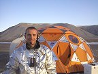
After dinner the crew presents me with a miniature model of a Mars Direct habitat lander, complete
with miniature tuna-can habs made of - what else- Chicken of the Sea tuna cans! They get me to
pose with the thing for the camera. It's a fun moment.
Pascal then gave another briefing, covering both tomorrow's field operations and the upcoming
pullout. Some 23 people, complete with gear, need to be evacuated from the Island within 48 hours,
and the entire base camp removed as well. This is an operation of some complexity, involving about
7 Twin Otter flights. To make matters more complex, there is still important field work to do on
Thursday, involving most everyone, and several more people will be coming in. I watch as Pascal
figures the problem out, consulting with each person and arranging resources to support their final
work, and then deciding who needs to be pulled out when. It is apparent from this, as well as
all I had seen earlier in the week, that Pascal is a superb field leader.
Pascal then introduces the evening's event, which is to be a set of talks by Bill Clancey, Brian
Glass, Charles Cockell, and Wayne Pollard. Clancey talks about the use of the MARS in supporting
human factors studies, and illustrates his points by studies he conducted on the field team in
Haughton crater during this season. His insights are remarkable. Brian Glass, a scientist with
NASA Ames, then gave a talk about how the usefulness or non-usefulness of various types of
information technology will be brought to light by putting them to the test in a Mars Arctic
Research Station. Charles then discussed the kinds of insights into exobiological field research
that will be made available by Mars Arctic Research Station operations. Both Brian's and Charles
points are very strong, and together with Clancey's talk and Carol's of the day before convince me
that the Mars Society can and should publish a book under the title "Science at the Mars Arctic
Research Station" that collects papers from these and other authors to present a compelling case
for the base.
The final talk of the evening is by Wayne Pollard, a professor from McGill University, who is an
expert on Arctic ice geology. He gives a very interesting talk. I ask him if, in view of what he
knows, does he think that pingos are to be found on Mars. Pingos are large underground ice lenses.
Ice cannot exist for long on the surface of Mars at mid or low latitudes, but it could be available
in near pure form near the surface if pingos exist. Pollard says they are likely. The question then
becomes methods of detection. Ground penetrating radar is a leading candidate.
It is close to midnight when the talks end, but a number of us decide to take a hike up the Bruno
escarpment, a huge ridge of breccia that lines the crater's western rim. We look for gypsum
crystals and shatter cones and find some good ones. I get some great late-night (long shadows)
footage of the crater and camp for the Discover channel. Around 1:30 AM we get back to camp and the
RDF TV crew shows up and asks me for an interview. I agree. When the sun is up you don't feel
tired.
Thursday, July 28, 1999.
Shortly after Pascal's' morning briefing a Twin Otter shows up and delivers Peter Jess, an
experienced Arctic contractor based in Resolute. He is here to give his evaluation of the
construction problems that might or might not be posed by the two sites. The crater site is
logistically straightforward; the real question is whether the Ridge will be significantly more
difficult. Because time is short, Pascal elects to ferry the relevant team over to the ridge by
helicopter, instead of using the ATV's. It takes two trips; Jess and I arrive on the second flight.
On the way, I get some great aerial TV footage for Discover channel. We land on the Von Braun air
strip, and hike from there over to the Haynes Ridge. Jess's evaluation is that transporting
supplies by ATV trailer from the airstrip to the Ridge will not be too difficult. His main concern
is with water, as the Lowell Canal is now quite dry. However, on Wednesday, John Scutt had advanced
the idea that we put a weir, or small dam in the canal that would trap its early-season abundant
water, and thus create a little reservoir. This idea is relayed to Jess, and he agrees it is quite
feasible. Some other concerns are discussed, and all are resolved except the possibility of
excessive wind. This will be determined empirically by the weather stations we will enplace in
the fall. Overall, we are very encouraged, as it now appears very probable that locating the Mars
Arctic Research Station at the preferred site on Haynes Ridge will be practical.
While we are on the Ridge, Marcus, a grad student from Carnegie Mellon university gets his robotic
helicopter working, and manages to take beautiful video of the Ridge area from the air.
The Twin Otter that was supposed to come in the afternoon did not come, and there is some concern
that the second Twin Otter would not come at all today. However shortly after dinner, a Twin Otter
arrived carrying a group of US Marine Reservists from Texas, whose Lt. Col. is part of the mission
operations staff at NASA Johnson Space Center. An aviation crew, they decided to fly their C-130
to Resolute, and then come over to examine Devon Island for potential C-130 airstrips that could be
used to support our project. The officer's immediate judgment was that there would be no problem
landing a C-130 in the crater.
Then, even before the first Twin Otter could leave with the first contingent of our pullout, the
second Twin Otter shows up. Kurt and I are scheduled for this one, and I have to scramble to finish
packing, since it was not expected for many hours.
As we ascend in our plane, I look down and see Pascal Lee leading an ATV convoy of Marines across
the crater, heading towards the Von Braun Planitia area to search for additional C-130 landing
sites.
Friday, July 30, 1999.
We spend the day in Resolute, meeting one contingent after another of the returning base crew.
There is one additional incident of note; in a final helicopter sortie as part of his geomagnetic
survey of the crater area (which has discovered some interesting scientific anomalies), Brian
Glass spotted a polar bear, and managed to get some close up still photographs from 20 ft above.
Charles Cockell debates for a while how to get his fish to the US, and then decides the simplest
course is to send it to a Canadian specialist for study. Kurt and I make some use of the day
learning more about logistics support capabilities in Resolute. As befits a mission commander,
Pascal Lee is the last to depart the island and arrive at Resolute. Naturally, the first thing he
does is announce that there will be a briefing at 9 AM the following morning. There are still a
few things left to do.
Some images copyright © NASA. All rights reserved.